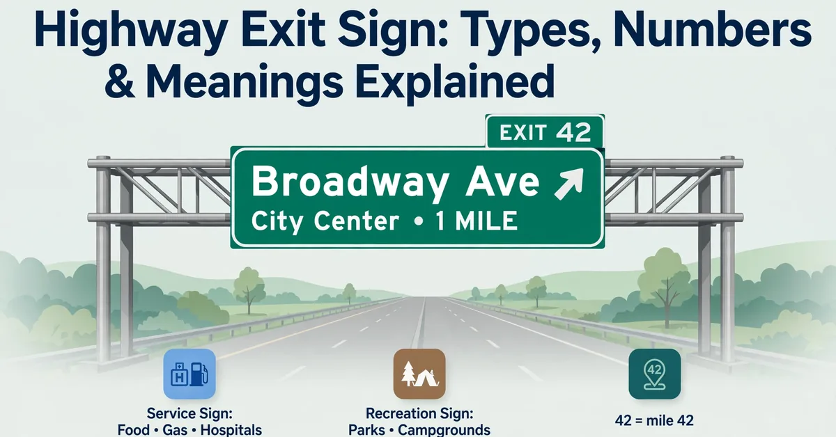
Highway Exit Sign: Types, Numbers & Meanings Explained
A highway exit sign is a green guide sign that tells drivers where a freeway ramp leaves the main roadway, which route or destination it serves, and which lane to follow. In the United States, these signs use standardized colors, exit numbers, arrows, distances, and lane-use panels so drivers can interpret them quickly at highway speed.
Reading an exit sign correctly matters most when traffic is heavy, interchanges are close together, or an unfamiliar highway splits into several ramps. The Federal Highway Administration’s Manual on Uniform Traffic Control Devices (MUTCD) establishes the national standards for guide signs, including exit numbering, sign placement, colors, and retroreflectivity (https://mutcd.fhwa.dot.gov/). This guide explains every major exit-sign type, how to read exit numbers, what the colors mean, and the mistakes drivers most often make.
Exit Sign: What Does It Mean?
A highway exit sign identifies a connection between a freeway or expressway and another roadway, street, or destination. The familiar green background and white lettering communicate guidance rather than a regulatory command. Depending on its position, a sign may announce an upcoming interchange, direct drivers into an exit lane, or mark the point where a ramp branches away.
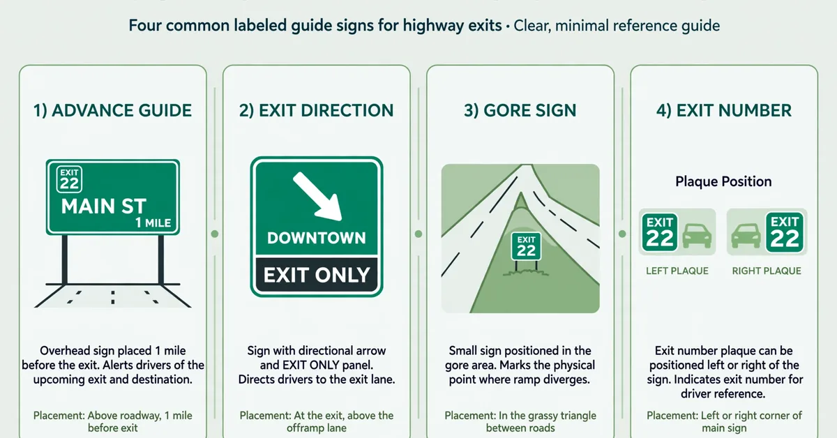
Not every exit sign serves the same purpose. An advance guide sign gives drivers time to prepare, an exit-direction sign confirms the intended movement, and an exit gore sign identifies the departure point. Together, these signs form a sequence intended to make route choices predictable and reduce sudden maneuvers.
The main parts of a highway exit sign
| Sign element | What it tells you |
|---|---|
| EXIT number | Identifies the interchange or exit |
| Letter suffix, such as A or B | Distinguishes exits associated with the same reference location |
| Destination or street name | Identifies the roadway or place served |
| Route shield | Identifies an Interstate, US route, or another designated route |
| Cardinal direction | Shows northbound, southbound, eastbound, or westbound travel |
| Distance line | Indicates how far away the interchange is |
| Arrow | Shows the intended movement or lane direction |
| EXIT ONLY panel | Warns that a lane is designated to leave the main roadway |
The exact combination depends on the interchange and sign type. A destination sign might name a cross street and city, while an overhead sign may show a route shield, an exit number, a direction, and arrows aligned with individual lanes. Read the entire sign assembly rather than relying on the word EXIT alone.
What to Do at a Highway Exit Sign
When you recognize an exit sign for your destination, plan your movement early. Check the route number, destination, distance, and arrows, then move into the appropriate lane when traffic conditions permit. Signal before changing lanes, maintain a safe following distance, and follow the lane markings and posted speed limits.
If you realize too late that your exit is approaching, do not brake abruptly in a through lane, swerve across traffic, or enter the painted gore area. Continue along the highway and use a later exit to reroute. Missing a turn is inconvenient; making a sudden maneuver at highway speed can put several vehicles at risk.
How to read an exit sign in sequence
Stage 1, Advance notice: Identify the exit number, destination, and route. Begin planning which lane you will need.
Stage 2, Lane preparation: Confirm the exit and make any necessary lane change safely and legally.
Stage 3, Exit direction: Follow the exit-direction sign, arrows, lane markings, and ramp alignment.
This is an illustrative sequence, not a universal placement schedule. The MUTCD describes advance-sign placement according to interchange classification, spacing, and roadway conditions (see MUTCD Section 2E.33). Major and intermediate interchanges commonly have signs at half a mile and one mile, with a two-mile sign where appropriate; minor interchanges may use a different arrangement.
Why Highway Exit Signs Exist
Exit signs exist because freeway exits must be identified consistently at highway speed. A driver typically has only seconds to interpret the exit number, destination, and arrows. The MUTCD’s guide-sign conventions use standardized color, letter height, spacing, and placement so drivers can locate the relevant information quickly and follow the correct lane.
The sequencing also matters. Signs that repeat the same exit number and destination reduce uncertainty when drivers are changing lanes or approaching a complex interchange. When an advance sign and an exit-direction sign tell the same story, a driver can confirm the decision instead of guessing at the last moment.
Exit-number placement: the left-versus-right clue
On Interstate guide signs, the position of the exit-number plaque often indicates which side the ramp is on. An exit-number plaque shown on the upper left of the guide sign usually means the exit is on the left, while a plaque on the upper right usually means the exit is on the right. The MUTCD distinguishes right-exit and left-exit number plaques (see Section 2E.31), and the Federal Highway Administration identifies this convention in its public explanations of Interstate guide signs.
This is a helpful clue, but it does not replace reading the arrows and lane markings. The plaque position should be read together with the arrow direction, route alignment, and lane markings, because unusual interchange layouts can differ.
Mile-Based vs. Sequential Exit Numbers
Most states use mile-based numbering on Interstates, but some still use sequential numbering. The difference affects how drivers interpret the exit number.
| Numbering system | How exit numbers are assigned |
|---|---|
| Mile-based | The exit number matches the nearest milepost |
| Sequential | Exits are numbered consecutively in travel order |
| Letter-suffixed (A, B, C) | Multiple ramps share one reference location |
Under a mile-based system, the exit number tells you where you are along the highway. Exits may be spaced unevenly, and skipped numbers are normal when interchanges are far apart. A suffix such as A or B can identify multiple ramps associated with the same milepoint. The Interstate system generally uses mile-based numbering, with numbers increasing south to north and west to east.
Sequential numbering gives exits consecutive numbers in travel order. Some states have converted from sequential to mile-based numbering. Where sequential numbers remain, the number itself does not reveal the distance between interchanges, and state practices may differ. For a current state-by-state reference, see the AARoads highway exit-numbering reference and confirm with the state DOT.
How mile-based exit numbering works
In a mile-based system, each exit number corresponds to the nearest milepost along the route. If you pass Exit 42 and the next interchange is Exit 47, you know roughly five miles separate them. This makes the exit number a position indicator as well as an identifier.
Letter suffixes handle cases where multiple ramps share one milepoint. Exits 42A and 42B, for example, are separate ramps associated with mile 42. The suffix does not indicate direction; the destination name, cardinal direction, and arrows provide that information.
How sequential exit numbering works
In a sequential system, the first interchange in the travel direction is Exit 1, the next is Exit 2, and so on. The numbers reveal the order of exits but not the distance between them. Two consecutive exits could be half a mile or ten miles apart.
A handful of states retained sequential numbering on some routes even as most converted to mile-based systems. Drivers should check the state DOT for the local system rather than assuming one convention applies everywhere.
Do exit numbers reset at state lines?
On the Interstate system, exit numbers generally increase south to north and west to east within each state, and they typically restart at state lines because mileposts themselves reset at the boundary. Drivers crossing a state border should expect the numbering to begin again.
This is a general practice, not an unbroken national sequence. The FHWA’s Interstate System overview (https://highways.dot.gov/highway-history/interstate-system) describes the system’s organization; numbering details remain subject to state implementation.
Commonly Confused Highway Signs
Highway exit signs are sometimes confused with other roadway signs because several sign families share the same green background. A destination guide sign, for example, may name an upcoming city without identifying an exit. A milepost or mile marker shows the distance along a route but does not itself mark a ramp.
The distinguishing features are the exit number, the word EXIT, and arrows or lane markings that show an exiting movement. If a sign names a destination but does not include an exit number or exit-specific direction, it may be providing general guidance rather than marking a ramp departure.
Destination guide sign
A destination guide sign names a city, town, route, or service ahead and may include a distance. It does not necessarily identify an exit. The presence of an exit number and exit arrows is what distinguishes an exit-direction sign from a general destination sign.
Milepost or mile marker
Mileposts are small roadside markers that show the mile number along a highway. They are reference points for navigation, emergency response, and mile-based exit numbering. A milepost alone does not mean an exit is present.
Junction sign
A junction sign indicates where two routes meet or where a route begins or ends. It may appear near an interchange but does not by itself identify an exit movement. The exit number and arrows provide the departure information.
Types of Highway Exit Signs
Not all exit signs look alike. Each type serves a specific function in the sequence from advance notice to the physical departure point. Understanding the types helps drivers know what to expect at each stage.
Advance guide signs
Advance guide signs appear before an interchange and give drivers time to prepare for a lane change. They may repeat the exit number, destination, and distance over several miles. An exit-direction sign appears at or near the ramp and confirms the intended movement.
The two types work as a pair. The advance sign answers the question, “Is this my exit?” The exit-direction sign answers, “Which lane do I take right now?” Reading both reduces the need for last-second decisions.
Exit-direction signs
Exit-direction signs appear at or near the ramp and confirm the intended movement with the exit number, destination, and a directional arrow. They are the final instruction before the gore point.
Exit gore signs
An exit gore sign is placed in the gore area,the triangular space between the main roadway and the departing ramp. Design details vary by sign type and installation: the FHWA’s Standard Highway Signs catalog includes exit-gore designs both with and without an exit number (E5-1 series; see MUTCD Section 2E.37), and arrow or chevron treatments differ across applications.
The gore area itself is not a travel lane, and it is distinct from the ramp that carries traffic away from the freeway. Drivers should not stop, reverse, or cut across the gore to reach an exit. The gore sign marks the physical point of departure; it is the final confirmation of the ramp’s location, not an invitation to enter the paved triangle.
EXIT ONLY panels and arrow-per-lane signs
An EXIT ONLY panel warns that a lane is designated to leave the freeway. Panel and arrow designs vary by application: the MUTCD specifies exit-only panels with directional arrows for certain exit-direction signs and lane-drop configurations (see Sections 2E.28 and 2E.39). Drivers should follow the complete sign, the arrow positioned over their lane, and the pavement markings,not any single remembered arrangement.
Arrow-per-lane signs are used for specified lane configurations, particularly freeway and expressway splits and multi-lane exits where an optional lane serves both the exiting and through movements. Each arrow is aligned with one lane on an overhead gantry, showing which lanes continue and which leave. Reading the arrow above your lane,together with its destination legend,is the most reliable way to confirm whether you need to change lanes.
Diagrammatic signs and multi-exit interchanges
Diagrammatic signs use simplified lane diagrams to show how lanes divide at a complex interchange. They are especially useful where a single roadway splits into several ramps or where an exit has multiple destinations. The diagram helps drivers match their lane to the correct branch.
At multi-exit interchanges, signs may show several exit numbers, letter suffixes, or destination names in a single assembly. Reading the full sign,not just the first line,prevents drivers from following the wrong branch when ramps diverge close together.
NEXT EXIT and “Next X Exits” Panels
A NEXT EXIT panel identifies the services or destinations available at the immediately upcoming interchange. A “next X exits” panel lists services across the next several exits. These panels help drivers plan fuel, food, or lodging stops without leaving the highway prematurely.
These are informational panels, not exit-direction signs. They tell you what is available ahead, but the exit-direction sign and arrows still govern the actual lane movement. Panel designs follow MUTCD conventions for supplemental guide signing.
Highway Sign Colors: Green, Blue, and Brown
Highway exit signs belong to the broader guide-sign family, which provides route, destination, and service information. The MUTCD assigns background colors to sign functions so drivers can recognize a sign’s purpose at a glance (see MUTCD Part 2 for sign color provisions).
| Color | Meaning |
|---|---|
| Green | Guide and directional information |
| Blue | Motorist services |
| Brown | Recreation and cultural interest |
Why highway exit signs are green
Green is the MUTCD-assigned background color for guide signs, which provide route, destination, and directional information on freeways and expressways. White lettering supplies the contrast needed for legibility at speed and distance.
Blue service signs versus brown recreation signs
Blue signs indicate motorist services such as gas, food, lodging, hospitals, and tourist information. They may appear as standalone signs or as panels listing services at upcoming exits. The specific services shown depend on the sign and location,a blue panel does not guarantee every listed service at every exit.
Brown signs indicate recreational or cultural points of interest, such as parks, historic sites, or scenic areas. Neither blue nor brown signs mark an exit movement by themselves. They provide information about what is available, while the green exit-direction sign identifies the ramp. Confusing a blue service panel with an exit-direction sign can lead drivers to change lanes unnecessarily.
Nighttime visibility and retroreflectivity
Guide signs use retroreflective sheeting so they remain legible at night when illuminated by headlights. The MUTCD establishes minimum retroreflectivity levels for traffic signs (see Section 2A.22) and standard layouts for freeway guide signing (see Section 2E.03). Agencies inspect, clean, and replace signs to maintain nighttime visibility.
Common Highway Exit Sign Mistakes
Drivers can misread exit signs when they focus on one element,usually the destination name,and miss the exit number, arrow, or lane-use panel. The mistakes below are among the most common, and each is avoidable by reading the complete sign assembly early.
- Staying in an EXIT ONLY lane when you intend to continue on the freeway.
- Making a last-second lane change across solid lines to reach an exit.
- Confusing a blue service sign with a green exit-direction sign.
- Reading only the destination name and missing the exit number or arrow.
- Following a GPS instruction that contradicts the posted signs and lane markings.
- Stopping or reversing in the gore area to catch a missed exit.
The safest habit is to read the full sign assembly,exit number, destination, distance, and arrows,well before the interchange. When in doubt, continue to the next exit and reroute rather than making a sudden maneuver.
Test your road-sign knowledge
If you want to check how well you read exit signs and other roadway signs, try our road sign practice test. You can also review related signs such as the dead end sign meaning and the green arrow traffic sign.
Exit Sign: Frequently Asked Questions
1. What does the exit number position mean?
On Interstate guide signs, an exit-number plaque shown on the upper left of the sign usually indicates a left exit, while a plaque on the upper right usually indicates a right exit. The MUTCD distinguishes right-exit and left-exit number plaques, and the Federal Highway Administration identifies this convention in its explanations of Interstate guide signs. Always confirm with the arrows and lane markings.
2. Why are highway exit signs green?
Green is the MUTCD-assigned background color for guide signs, which provides route, destination, and directional information. The green background with white lettering distinguishes guidance from regulatory, warning, service (blue), and recreation (brown) signs under the MUTCD’s color provisions.
3. What are blue highway signs for?
Blue signs indicate motorist services such as gas, food, lodging, hospitals, and tourist information. They may appear as standalone signs or as panels listing services available at upcoming exits. The services shown depend on the location.
4. What does EXIT ONLY mean?
EXIT ONLY means the lane is designated to leave the freeway. A driver who stays in that lane will be carried onto the exit ramp. Panel and arrow designs vary by application; follow the complete sign, the arrow over your lane, and the pavement markings.
5. What is the difference between mile-based and sequential exit numbers?
Mile-based exit numbers match the nearest milepost, so the number indicates your position along the highway. Sequential numbers are assigned in travel order and do not indicate distance. Most states use mile-based numbering on Interstates; check the state DOT and a current state-by-state reference for the local system.
6. Do exit numbers reset at state lines?
On the Interstate system, exit numbers generally increase south to north and west to east within each state, and they typically restart at state lines because mileposts themselves reset at the boundary. This is a general practice, not an unbroken national sequence.
7. What is an exit gore sign?
An exit gore sign is placed in the gore area,the paved triangle between the main roadway and the departing ramp. Design details vary by sign type and installation; the FHWA catalog includes exit-gore designs both with and without an exit number. The gore area is not a travel lane.
8. What is a diagrammatic sign?
A diagrammatic sign uses simplified lane diagrams to show how lanes divide at a complex interchange. It helps drivers match their lane to the correct ramp when a roadway splits into multiple branches.
9. What should I do if I miss my exit?
Continue on the highway and use a later exit to reroute. Do not brake abruptly, swerve across lanes, or reverse in the gore area. Missing an exit is inconvenient; a sudden maneuver at highway speed is dangerous.
Conclusion
A highway exit sign is a green guide sign that identifies where a ramp leaves the freeway, which route or destination it serves, and which lane to follow. Reading the exit number, destination, distance, and arrows as a complete assembly,rather than relying on any single element,is the key to navigating interchanges safely.
The exit-number plaque position offers a useful left-versus-right clue, mile-based numbering reveals your position along the route, and panels such as EXIT ONLY, NEXT EXIT, and arrow-per-lane signs provide lane-specific guidance. Blue service signs and brown recreation signs add information about what is available, but only the green exit-direction sign marks the ramp itself.
For authoritative standards, consult the FHWA MUTCD guide-sign standards (https://mutcd.fhwa.dot.gov/) and a current state-by-state exit-numbering reference such as the AARoads highway guides for numbering systems. With these conventions understood, drivers can approach any interchange with confidence instead of guessing at the last moment.

Jack Harrison is a contributor at Square Root Signs, sharing creative ideas, useful information, and engaging content to help readers discover something valuable with every visit.